The Best (and Worst) App of All Time

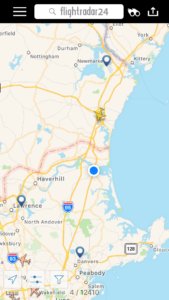
Flightradar 24 in map mode. You can see that a jet from London Heathrow headed for JFK in New York City is a few miles north of my location in Newburyport.

I’d be the first to acknowledge that the proliferation of so-called “smart phones” has been a major contributing factor in the decline of human civilization over the past couple of decades. Between the stupid games and the instant access to an infinite supply of useless information and the ever-expanding social media options — and occasionally, GASP!, the ability to actually communicate with other real, live people — having a supercomputer in your pocket has not created the Great Society some may have hoped for.

So it is with a mixture of pride and shame that I share with you an app I believe is absolutely awesome. Or the worst thing ever. Or, more likely, both.

It’s called Flightradar 24 and if you’re a geek, nerd, travel buff or just dig airplanes, you gotta have it. I think I paid $4.99 for it and while I am usually loath to pay for an app, I’m glad I paid for this one. There’s a free website of the same name (which is how I found the app) and it’s a good introduction to what the app is all about — a try-before-you-buy plan, so to speak.

What Flightradar does is combine your location and air-traffic data from all over the world. So when you see that airliner leaving a vapor trail overhead, you can find out what airline it is, where it’s coming from, where it’s going to, it’s altitude, speed, vertical speed, geographic location and more. It’s an aviation geek’s wet dream and while I’ve yet to actually orgasm, I have become slightly addicted to the damned thing.

And therein lies its negative attribute: once you start using it, you can’t stop. Whether you’re on the beach, out for a hike, in the city, on the golf course or anywhere else, inside or out, sunshine or rain, you’ll see or hear a plane going overhead and you can’t NOT pull out the app and see who it is. Sometimes ignorance CAN be bliss, but with Flightradar in your pocket, a vapor trail generates a hypnotically induced reaction: you reach into your pocket and pull out your phone because you…can’t. Help. It.

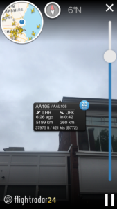
Here’s that same flight using the iPhone’s camera to find it by sight. This photo would be more impressive if it wasn’t overcast today.

On top of that, the compass and gyroscope-thingie in the iPhone (I can’t speak for how it works on non-Apple platforms) can determine where you are so when you set the app to visual mode, you can just point the camera at the plane and…voila! It’s too damned easy.

It really is mindless fun and useless information. But again, if you’re a plane geek, you’ll dig Flightradar. Living where I do — on the coast about 30 miles north of Boston — there are certain times of the day where an armada of jets from Europe passes overhead, and other times when that same armada is headed overseas. It’s cool to sit on my deck and watch the blinking navigation lights head out to sea and be able to know it’s an Aer Lingus flight headed for Shannon, Ireland, or a freight-carrying 747 headed for Luxembourg. At certain times of the day, depending the sun’s position in the sky, I can see the airline logos on the fuselage and tail with binoculars and match the plane up with the data in the app. (Like I said: it’s for geeks and nerds.)

Thus far, I’ve seen some pretty far out departure and destination cities. Sure, there ample flights to and from London, Paris and Zurich. But then there are the flights to and from Qatar, Moscow and Oslo; Tel Aviv, Milan and Istanbul; Beijing, Reykjavik and Madrid. Some of the more interesting (to me, anyway) flights I’ve seen have been from some Europe direct to Havana and Mexico City.

There’s one other problem with the app, in addition to being a serious attention-grabber and time-suck. Plenty’s the time I’ve seen a flight coursing above me, looked up the info on my phone and wished I’d been on the plane. Flightradar definitely adds to the wanderlust.

On The Road…again

Version 2

At the starting line: Seaside Reef in Cardiff, California

I first drove across the United States during the summer of 1982. My mother and I loaded up our family’s 1970s-era American station wagon — you know the kind: huge V-8 engine, body big enough to land planes on, trunk/jump seats in the back..the kind of station wagon the Griswolds drove to WallyWorld — and headed west to my brother’s wedding in Utah. I was 16 years old and my mother had insisted I get my driver’s license as soon as I was eligible so I could help with the driving.

Once we got past Philadelphia, I drove every mile of the trip. And it created a character trait/flaw that persists to this day.

IMG_1840

The part of SoCal they don’t show in the tourist brochures

Over the recent Memorial Day weekend I packed my Subaru Outback — a slightly smaller wagon than before — and drove from San Diego to northern Massachusetts. It’s about as long a drive as you can make and still be in the United States, and it was the latest of I-don’t-know-how-many mega drives I’ve done to this point in my life. By “mega drive” I mean something covering at least a couple of thousand miles; something requiring multiple days of all-day driving, so this includes my drives between Alaska and the Lower 48. I’ve done mega drives in that beast of a wagon and a rented Ford Escort wagon, a pair of Subarus, a ’73 Volkswagen convertible and a ’78 Volkswagen camper van, a Ford Ranger and a beast of an F-250 pickup. I’ve done the drives in high summer amid thunderstorms and blazing heat, and I’ve done the drives in a Wyoming white-out blizzard where the snow was door-deep. I’ve covered (from north to south) I-90, 80, 70, 40, 10 and 8, and I’ve covered (from west to east) I-5, 15, 25, 35, and 95. And en route to and from Alaska, I’ve covered the northwestern U.S. and western Canada from the Calgary-Edmonton corridor west to the coast. I’ve done the drives leisurely (that first drive with Mom we stopped each day after six to 10 hours of driving and got a hotel or stayed with friends of hers) and I’ve done the drives with full-on white-line fever (the legal kind: none of that pixie dust for me ever): from Idaho to Anchorage in three days; 19 hours from the East Coast to Des Moines, a six-hour sleep in a rest area, and 17 more hours to Park City.

And so on. My point is: I’ve covered a lot of miles in this country in a wide range of fashions. And every time I’ve done a mega drive I’ve sworn: never again.  But despite the wearying fatigue that results from such trips, I keep packin’ up and headin’ out. Why?

IMG_1846

Who knew Arizona could be so green? This isn’t even the good part.

Because just as that trip in 1982 was an eye-opening journey, the drive a couple of weeks ago reminded me of what a great way to see this amazing land a cross-country drive can be. Because even if you’re going 100 bleary-eyed miles an hour, you can get a sense for this continent that you’ll never get from 33,000 feet up.

You’ll see that there’s a lot more non-urban area than you think. For instance: westerners have an image of the northeast as one paved-over cityscape, but the reality is that just 25 miles or so outside of New York City, you’re in the woods. Hell, parts of Pennsylvania and New York and Connecticut are practically jungles. There’s a lot more land out there than people think. No, it’s not wilderness in the Bob Marshall sense of the word, but it’s still pretty green and full of non-human life. And a drive at this time of year was particularly green, with trees in bud, wildflowers lining the highways, and crops and fields emerging into summer sunshine from beneath winter storms and spring runs.

You’ll also find some interesting surprises every single time you drive across the country. On this drive, I learned that Arizona is not all one big desert; the mountains of central Arizona are high and green and forested and wild. Who knew? I learned that Oklahoma is way greener and wooded than I expected; it’s not a grapes-of-wrath dust bowl (at least not in May 2016, it’s not).

IMG_1849

Along the way, you just might find out what your true calling is…

On the other hand, you’ll see that malls are taking over this country and they all look the same, with the same architecture and having the exact same stores. From Orange County to Oklahoma to New England, we are becoming so homogenized in terms of our experiences that all the chest-thumping regionalism is self-delusional. Nowadays, we all go to the same stores and eat in the same restaurants and hear the same music and see the same signs. Yes, food stuffs will differ slightly, but only if you get out of the TGI Fridays and Chilis (never mind the fast-food chains and Starbucks).

And everywhere along the way you’ll see that our infrastructure is in grotesque shape. Yes, grotesque. The interstate highways are an embarrassment and dangerous, and despite the complaining everyone will do when held up by a construction zone, there aren’t enough projects underway to get our roads and bridges and such back into safe, efficient shape. Political sidebar: If we took those billions we’re spending on the new fighter plane that gets outperformed by existing aircraft, or on a new nuclear submarine in an era of non-state threats, and directed that money toward our infrastructure, we’d not only get our transport systems back up to snuff but we’d also put thousands of Americans to work. I call that a win-win and well worth tacking on an extra half an hour to the drive.

You’ll realize that Americans are shitty drivers. In this culture where driving is treated like a right instead of a privilege, rude and downright unsafe driving habits are the norm. Drivers speeding up when they start to get passed, slow drivers living in the left lane, people making turns across several lines or not merging (or allowing a merge) when lanes constrict — and don’t even get me started on the dearth of turn-signal usage — you see the same shitty driving everywhere. I used to think that there were more shitty drivers in California than elsewhere, but I now realize that the percentages are about the same everywhere. It’s just that in California, where there are simply so many people and such a car culture, the raw numbers are so much higher. But percentage-wise, California is no worse than anywhere else in the U.S. (and after a couple of weeks being back in New England, I’m actually coming around to the mindset that the percentages are higher here). I, for one, can’t wait for the driverless automobiles. Our traffic will disappear when the machines are doing the driving for us.

IMG_1859

Made it. And in time for game one of the Stanley Cup finals, too.

My recent drive was actually pretty straightforward: three days (of 13, 14 and 12 hours, respectively) from central Arizona to home at Plum Island. The traffic was light until I hit northeast Pennsylvania and southwestern Connecticut, and the weather was fine the entire way. My Subaru ran like a top and I didn’t wind up with a back that felt like I’d been through medieval torture. And I wound up back home for at least the time being for less money than a one-way plane ticket — AND I don’t have to rent a car while I’m here.

Oh, and for you Californians reading this: the rumors are true. Gas IS affordable in America. Once you get east of the border, into Nevada or Arizona, gas prices drop a full half-dollar or more.

So it was a relatively easy drive this time but I once again declared, “Never again” when I pulled into the driveway at home. That is, until I get that wanderin’ jones again and head out on the highway. I’d say…July, at least.